Light Pollution Map: Find Dark Skies, Track Auroras & Explore the Night Sky
Find darker skies, see more stars, and discover the best conditions for stargazing and astrophotography.
Light Pollution Map is an all-in-one dark sky finder, aurora borealis tracker, and astronomy planning app designed to help you explore the night sky.
Whether you’re searching for a dark location to see the Milky Way, planning an astrophotography session, tracking the northern lights, or preparing to watch a meteor shower, Light Pollution Map brings essential astronomy and weather tools together in one convenient app.
Explore detailed light pollution maps, Bortle scale estimates, live sky conditions, aurora forecasts, Moon phases, International Space Station tracking, astronomy events, and much more.
Find the Best Places for Stargazing With a Light Pollution Map
Artificial light from cities, towns, and developed areas can make thousands of stars disappear from view. Finding darker skies is one of the most important steps toward enjoying better stargazing and astrophotography.
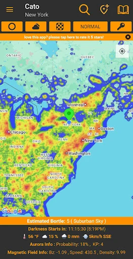
Light Pollution Map helps you find dark sky locations near you by displaying a detailed light pollution overlay on an interactive map.
Explore the surrounding area, compare locations, and identify places where artificial light pollution may have less impact on your view of the night sky.
Interactive Dark Sky Map
Use the interactive map to explore light pollution levels across different locations.
- Light Pollution Overlay: Visualize estimated artificial light pollution across the map.
- Bortle Scale Estimates: Compare approximate night sky darkness levels at different locations.
- Adjustable Overlay Opacity: Customize how light pollution information appears over the map.
- Multiple Map Types: Switch between different map views to explore potential observing locations.
- Horizon Safe Radius: Identify areas with greater separation from surrounding sources of light pollution.
Whether you’re looking for a nearby stargazing spot or planning a trip to a remote dark sky destination, Light Pollution Map helps you make more informed decisions about where to observe.
Bortle Scale Map: Understand How Dark the Night Sky Is
The Bortle Scale is a nine-level system used to describe the darkness and quality of the night sky, ranging from exceptionally dark locations to heavily light-polluted urban skies.
Light Pollution Map provides estimated Bortle scale information to help you compare potential observing locations.
What Do Bortle Scale Ratings Mean?
- Bortle Class 1: Exceptionally dark skies with outstanding visibility of faint celestial objects.
- Bortle Class 2: Very dark skies, excellent for observing and astrophotography.
- Bortle Class 3: Rural skies with relatively low light pollution.
- Bortle Class 4: Rural-to-suburban transition skies with some noticeable light pollution.
- Bortle Class 5: Suburban skies where light pollution becomes more significant.
- Bortle Class 6: Bright suburban skies with reduced visibility of faint stars.
- Bortle Class 7: Suburban-to-urban skies affected by substantial artificial lighting.
- Bortle Class 8: City skies where relatively few stars remain visible.
- Bortle Class 9: Bright inner-city skies with severe light pollution.
Lower Bortle classes generally indicate darker skies, making them especially desirable for Milky Way photography, deep sky observation, and meteor shower viewing.
Bortle classes displayed in the app are estimates. Actual sky darkness depends on local conditions, weather, atmospheric clarity, and nearby lighting.
Milky Way Photography and Dark Sky Location Planning
Want to photograph the Milky Way but aren’t sure where to go?
Light Pollution Map helps astrophotographers locate areas with less artificial light, an important factor when capturing the faint details of our galaxy.
Combine light pollution information with weather forecasts, Moon phases, and astronomical darkness times to plan more promising Milky Way photography sessions.
Whether you’re using a DSLR, mirrorless camera, telescope, or smartphone, finding a darker location can make a dramatic difference in the stars and celestial details you can observe or photograph.
Remember that Milky Way visibility also depends on the time of year, your location, the Moon, and atmospheric conditions.
Live Stargazing Weather Forecasts and Sky Conditions
A dark location isn’t always enough for great stargazing. Clouds, precipitation, wind, and other weather conditions can determine whether an observing session is worthwhile.
Light Pollution Map includes live weather and sky condition information to help you evaluate conditions before heading outside.
Check important weather factors, including:
- Cloud Cover: Evaluate whether clouds may obstruct your view of the stars.
- Temperature: Prepare for outdoor observing conditions.
- Wind: Check conditions that may affect telescope stability and outdoor comfort.
- Precipitation: Monitor rain and other weather that could interrupt observing sessions.
- Additional Weather Data: Explore other conditions relevant to your night sky plans.
Use these forecasts alongside the dark sky map to help decide both where and when to go stargazing.
Astronomical Darkness Timer: Know When True Night Begins
Sunset doesn’t mean the sky is immediately dark enough for astronomy.
After sunset, the sky passes through several twilight phases before reaching astronomical darkness, when the Sun is sufficiently far below the horizon for the darkest nighttime conditions under otherwise favorable circumstances.
Light Pollution Map includes an Astronomical Darkness Timer that shows when astronomical darkness begins and ends.
Use the live countdown to plan nighttime observations, astrophotography sessions, and other activities that benefit from darker skies.
This tool is especially useful for photographers who want to capture faint stars, the Milky Way, and deep sky objects.
Aurora Borealis Tracker and Northern Lights Forecast
Want to know whether the northern lights might be visible tonight?
Light Pollution Map includes a powerful aurora borealis tracker with space weather information to help you monitor conditions associated with aurora activity.
Whether you’re an experienced aurora chaser or hoping to see the northern lights for the first time, the app provides useful data for evaluating aurora viewing opportunities.
Live Aurora Forecast and Kp Index
Monitor important aurora and geomagnetic activity indicators, including:
- Kp Index: Track planetary geomagnetic activity associated with auroral displays.
- Aurora Probability: Explore forecast information about potential aurora visibility.
- Solar Wind Speed: Monitor solar wind conditions that can influence geomagnetic activity.
- Solar Wind Density: View additional solar wind measurements.
- Interplanetary Magnetic Field (Bz): Track magnetic field conditions relevant to the interaction between the solar wind and Earth’s magnetosphere.
These measurements can help you understand changing space weather conditions, although no single indicator guarantees that an aurora will be visible from your location.
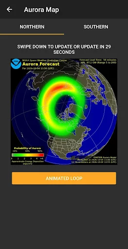
NOAA Aurora Forecast Maps
Explore NOAA aurora forecast maps for both the Northern and Southern Hemispheres.
These maps provide a visual overview of forecast auroral activity, helping you monitor potential northern lights and southern lights viewing regions.
For the best viewing opportunities, combine aurora forecasts with local cloud cover, darkness, light pollution, and your geographic location.
Live Aurora Webcams and Space Weather Feeds
Explore space weather and aurora activity through live imagery and scientific data feeds.
Light Pollution Map includes access to:
- Live Aurora Webcams: Watch aurora activity from locations around the world.
- NASA SOHO Solar Imagery: Explore current imagery of the Sun from the Solar and Heliospheric Observatory.
- Magnetosphere Data: Monitor live information about Earth’s magnetic environment.
These tools are useful for aurora enthusiasts, astronomy hobbyists, and anyone interested in solar activity and space weather.
Moon Phase Calendar and Moon Position Tools
The Moon can dramatically influence nighttime observing conditions.
A bright Moon can wash out faint stars and reduce the visibility of the Milky Way, while moonlight can also create beautiful opportunities for landscape and nighttime photography.
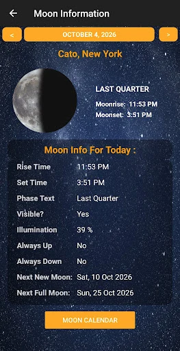
Light Pollution Map includes detailed Moon phase and lunar information to help you plan around the Moon.
Moon Phases, Illumination, Moonrise and Moonset
Access important lunar information, including:
- Current Moon phase
- Moon illumination percentage
- Moonrise and moonset times
- Additional lunar information
Use Moon phase information to identify nights with less moonlight for stargazing, or plan photography sessions that incorporate the Moon into your composition.
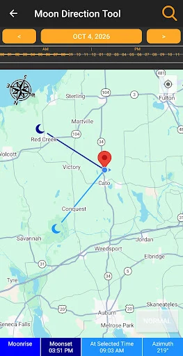
Moon Position and Direction Tool
Light Pollution Map includes a Moon Position Tool that helps you visualize the Moon’s azimuth.
Use it to plan landscape astrophotography compositions, explore lunar direction, and better understand where the Moon will appear relative to your observing location.
International Space Station Tracker and ISS Flyover Alerts
Ever looked up and wondered whether the bright object moving across the sky was the International Space Station?
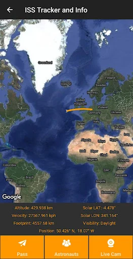
Light Pollution Map includes a dedicated ISS tracker to help you follow the International Space Station and prepare for upcoming flyovers.
Live ISS Location Map
Track the International Space Station’s location as it travels around Earth using an interactive live map.
ISS Flyover Notifications
Receive alerts for upcoming ISS flyovers near your location, helping you prepare to watch the station pass overhead.
Live ISS Video and Crew Information
Explore additional ISS features, including:
- Live International Space Station video feeds
- Current ISS crew information
- Real-time ISS tracking information
Whether you’re interested in space exploration, satellite spotting, or photographing the ISS, these tools help you stay connected to activity in low Earth orbit.
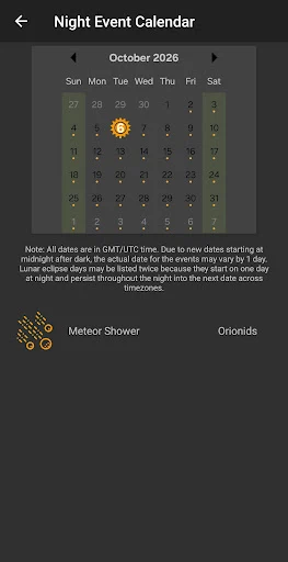
Astronomy Events Calendar: Meteor Showers, Eclipses and Supermoons
Don’t miss exciting events happening in the night sky.
Light Pollution Map includes a Night Sky Calendar featuring upcoming astronomical events and celestial phenomena.
Discover events such as:
- Meteor Showers: Plan around major annual meteor shower activity.
- Lunar Eclipses: Discover upcoming opportunities to observe eclipses of the Moon.
- Supermoons: Stay informed about notable full Moon events.
- Other Astronomy Events: Explore additional celestial events throughout the year.
Combine the astronomy calendar with weather forecasts, light pollution information, and Moon phases to help plan your next observing session.
Custom Astronomy and Aurora Alerts
Some of the best night sky experiences happen when you least expect them.
Light Pollution Map includes custom astronomy notifications to help you stay informed about important celestial events and changing space weather conditions.
Available alert categories include:
- Local aurora activity
- Global aurora activity
- Meteor showers
- Supermoons
- Eclipses
- International Space Station flyovers
- Other notable astronomy events
Instead of repeatedly checking multiple astronomy websites, use Light Pollution Map to keep track of the events that interest you.
Astrophotography Calculators and Astronomy Tools
Planning astrophotography or working with a telescope often involves technical calculations.
Light Pollution Map includes a collection of astronomy and astrophotography calculators designed to make these tasks easier.
Telescope Magnification Calculator
Calculate telescope magnification using telescope and eyepiece specifications to better understand your observing setup.
Star Trail Calculator
Explore calculations related to star trail photography and plan creative long-exposure images of the night sky.
Orbital Period Calculator
Calculate orbital periods using relevant orbital parameters.
Astronomical Unit Conversions
Convert between astronomical units and other distance measurements used in astronomy.
These built-in tools give astronomy enthusiasts and astrophotographers convenient access to useful calculations.
Save Your Favorite Dark Sky and Stargazing Locations
Found a great location for stargazing or astrophotography? Save it for future visits.
Light Pollution Map includes a Location Manager that lets you save favorite observing sites and dark sky destinations.
Quickly return to your preferred locations when planning future astronomy sessions, checking sky conditions, or comparing potential observing sites.
Astronomy Photo of the Day
Discover the beauty of space with a new astronomy and space image every day.
Explore fascinating celestial objects, astronomical phenomena, and images that inspire curiosity about the universe.
Home Screen Widgets for Aurora, Weather and Astronomy
Keep important night sky information conveniently accessible with Light Pollution Map’s home screen widgets.
Available widget information includes:
- Aurora conditions
- Cloud cover
- Temperature
- Astronomy photos
- Astronomical darkness times
Check useful astronomy and weather information directly from your device’s home screen.
Night Mode and AMOLED Themes for Stargazing
Bright smartphone screens can interfere with your eyes’ adaptation to darkness during nighttime observing.
Light Pollution Map includes Night and AMOLED themes designed to provide a darker interface while using the app outdoors at night.
These themes help reduce bright screen elements and can make nighttime use more comfortable.
AMOLED themes can also take advantage of the display characteristics of compatible devices.
For the best night vision preservation, keep your device brightness low and consider additional red-light precautions when appropriate.
Who Is Light Pollution Map Designed For?
Light Pollution Map brings together tools for a wide variety of night sky enthusiasts.
- Stargazers: Find darker skies and check observing conditions before heading outside.
- Astrophotographers: Plan Milky Way photography, star trails, and nighttime compositions.
- Aurora Chasers: Monitor northern lights forecasts, geomagnetic activity, and solar wind conditions.
- Astronomy Enthusiasts: Follow meteor showers, eclipses, supermoons, and other celestial events.
- Telescope Owners: Find observing locations and use helpful astronomy calculators.
- Night Sky Photographers: Combine darkness, weather, and Moon information when planning sessions.
- Space Enthusiasts: Track the ISS, explore solar imagery, and discover astronomy photographs.
- Travelers and Campers: Locate darker destinations and enjoy more rewarding nights under the stars.
Light Pollution Map Pro: Unlock Additional Astronomy Features
Light Pollution Map offers a powerful collection of stargazing and astronomy tools, with additional functionality available through an optional Pro subscription.
Pro helps support continued app development, improvements, and the addition of new astronomy features.
Some tools and features require an active Pro subscription. Check the app for current subscription options, pricing, and feature availability.
Frequently Asked Questions About Light Pollution Map
How can I find dark skies near me?
Use a light pollution map to compare estimated artificial light levels in your surrounding area. Light Pollution Map helps you identify darker locations using an interactive map, light pollution overlays, and Bortle scale estimates.
What is the Bortle Scale?
The Bortle Scale is a nine-level system used to describe night sky darkness. Class 1 represents exceptionally dark skies, while Class 9 represents heavily light-polluted inner-city skies. Lower Bortle classes generally offer better conditions for observing faint stars and deep sky objects.
Where is the best place to see the Milky Way?
The Milky Way is generally easier to observe from locations with low light pollution, clear skies, and minimal moonlight. Light Pollution Map can help you identify darker locations and evaluate weather and Moon conditions before planning your trip.
Can Light Pollution Map predict the northern lights?
Light Pollution Map provides aurora forecast information, Kp index readings, solar wind measurements, and NOAA aurora maps. These tools help you evaluate the potential for aurora activity, although actual visibility depends on location, darkness, weather, and changing space weather conditions.
What Kp index is needed to see the northern lights?
The Kp index measures global geomagnetic activity on a scale from 0 to 9. Higher values generally indicate stronger geomagnetic activity and the potential for auroras to extend farther from polar regions. However, there is no single Kp threshold that guarantees aurora visibility at every location.
Does Light Pollution Map show Moon phases?
Yes. The app includes Moon phases, illumination, moonrise and moonset times, and a Moon Position Tool for planning nighttime observations and photography.
Can I track the International Space Station?
Yes. Light Pollution Map includes a live ISS tracker, location-based flyover alerts, live ISS video feeds, and current crew information.
Does Light Pollution Map show meteor showers and eclipses?
Yes. The Night Sky Calendar includes upcoming meteor showers, lunar eclipses, supermoons, and other notable astronomical events.
When does astronomical darkness begin?
Astronomical darkness generally begins after the Sun descends at least 18 degrees below the horizon and ends as astronomical twilight begins before sunrise. Light Pollution Map includes a timer showing astronomical darkness periods and a live countdown.
Is Light Pollution Map useful for astrophotography?
Yes. Light Pollution Map includes dark sky mapping, Bortle scale estimates, weather information, Moon tools, astronomical darkness times, star trail calculations, and other utilities that can help plan astrophotography sessions.
Is Light Pollution Map free?
Light Pollution Map includes accessible astronomy and stargazing features, while some advanced functionality requires an optional Pro subscription. Check the app for current feature availability and subscription details.
Download Light Pollution Map and Explore the Night Sky
Find darker skies. Chase the northern lights. Discover more of the universe.
From finding a dark place to photograph the Milky Way to monitoring aurora forecasts and planning your next meteor shower viewing, Light Pollution Map brings powerful astronomy tools together in one convenient app.
Whether you’re a beginner discovering the stars or an experienced astrophotographer planning your next adventure, Light Pollution Map helps you make the most of every clear night.
Download Light Pollution Map today and discover what you’ve been missing in the night sky!
Some features require a Pro subscription. Forecasts, sky darkness estimates, and celestial event visibility may vary by location and conditions.